U. S. Senate Committee on the District of Columbia. Senate Report No. 166, 57th Congress, 1st Session. Washington: Government Printing Office, 1902.
On January 15, 1902 the Senate Park Commission's report was accepted and approved by the Senate Committee on the District of Columbia, chaired by Senator James McMillan of Michigan. Ten months earlier McMillan after failing to obtain support from the House of Representatives, succeeded in gaining a Senate resolution authorizing the use of the Senate contingent fund to pay "such experts as may be necessary for a proper consideration" of the "development and improvement of the entire park system of the District of Columbia. McMillan's use of "park system" in his resolution was something less than honest. For it was clear that the Senator had in mind a comprehensive plan for future buildings and other uses of Federal land in central Washington as well as improvements in the system of park and recreation areas.
Senator McMillan named to the commission four distinguished designers: architects Daniel Burnham and Charles McKim, Sculptor Augustus St. Gaudens, and landscape architect Frederick Law Olmsted, Jr. A cruise along the Potomac to visit some of the great estates and a stop in Williamsburg gave the group a chance for preliminary discussions. Burnham then announced that he, McKim, and Olmsted were going to Europe to look at examples of urban design. On shipboard outbound and returning the group worked out preliminary plans for reshaping the monumental core of Washington in what they believed to be the spirit of the original L'Enfant plan of 1791. In Paris, Versailles, Rome, Venice, Vienna, Budapest, London, and Oxford the three designers accompanied by Charles Moore, McMillan's secretary and assistant refined their ideas.
Returning to the United States after the seven-week study and design tour, the Commission established three studios. One was in New York on the floor above the office of McKim, Mead, and White. Olmsted worked out of his offices in Brookline, Massachusetts where he assumed responsibility for the park plans. In Washington McMillan found space in a part of the Senate Press Gallery for a drafting room. On the day the report was approved by the Senate Committee on the District of Columbia an exhibit designed by McKim of the Commission's plans, perspectives, and models opened at the Corcoran Gallery. Visitors that day included President and Mrs. Theodore Roosevelt, many members of the Cabinet, and legislators from the House and Senate.
Of all the major plans for American cities the Senate Park Commission design for Washington was by far the most successful if judged by the number of recommendations that have been carried out. Of course, this took place over a long period of years and was a major responsibility of the Fine Arts Commission that came into existence in 1910. It is not too much to say that the central part of Washington today is almost entirely the result of the plan published and exhibited in 1902.
The long excerpt that follows is only part of the report. Omitted here are the sections that recommended park and recreation improvements, proposals that were also followed in most significant respects. The report was profusely illustrated, but the quality of black and white reproduction was not the highest except for the plan. The colored reproductions of several of the original large perspective renderings are from an issue of the National Geographic in 1913.
THE MALL SYSTEM
The City of Washington, during the century since its foundation, has been developed in the main according to the plan made in 1791 by Major Charles L'Enfant and approved by President Washington. That plan the Commission has aimed to restore, develop, and supplement.
The "Congress house" and the "President's palace," as he termed them, were the cardinal features of L'Enfant's plan; and these edifices he connected "by a grand avenue four hundred feet in breadth, and about a mile in length, bordered by gardens, ending in a slope from the houses on each side." At the point of intersection of two lines, one drawn through the center of the Capitol the other drawn through the center of the White House, L'Enfant fixed the site of an equestrian statue of General Washington, one of the numerous statues voted by the Continental Congress but never erected.
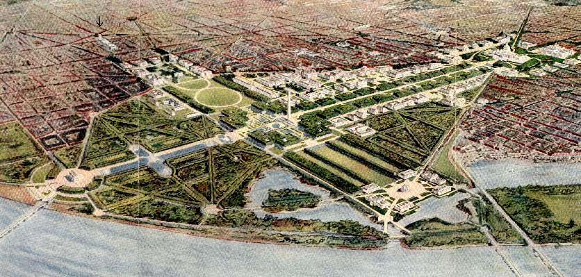
When, in 1848, the people began to build the Washington Monument, the engineers despaired of securing on the proper site a foundation sufficient for so great a structure; and consequently the Monument was located out of all relations with the buildings which it was intended to tie together in a single composition. To create these relations as originally planned was one of the chief problems of the Commission.
Again, the reclamation of the Potomac Flats, prosecuted since 1882, has added to the Monument grounds an area about one mile in length from east to west; so that where L'Enfant dealt with a composition one and a half miles in length, the Commission is called upon to deal with an area two and a half miles long, with a maximum breadth of about one mile.
By the inclusion of the space between Pennsylvania and New York avenues
on the north, and Maryland avenue and the Potomac River on the south, the
new composition becomes a symmetrical, polygonal, or kite-shaped, figure
bisected from east to west by the axis of the Capitol and from north to
south by the White House axis. Regarding the Monument as the center, the
Capitol as the base, and the White House as the extremity of one arm of
a Latin cross, we have at the head of the composition on the banks of the
Potomac a memorial site of the greatest possible dignity, with a second
and only less commanding site at the extremity of the second arm.

So extensive a composition, and one containing such important elements, does not exist elsewhere; and it is essential that the plan for its treatment shall combine simplicity with dignity.
The Capitol Division
The Capitol, located by Washington and L'Enfant on a site which seemed to the latter as "a pedestal waiting for a monument," was constructed in accordance with plans prepared by Thornton and selected by the first President and his Secretary of State, because among the number of designs submitted Thornton's alone displayed the dignified simplicity which should characterize the legislative halls of a nation. Under the personal direction of President Fillmore, the Capitol was extended by the addition of the Senate and the House wings, and the edifice was surmounted by a soaring dome, all designed by Thomas U. Walter. Distinguished alike for its historic associations and for its architectural merits, the Capitol stands in the midst of ample grounds, indeed, but is surrounded in the main by private buildings, many of them of the most squalid character, or by neglected stretches of land used as dumping grounds. From the Mall system the grounds are cut off by the Botanic Garden, walled and fenced so as to block the way.
 Click for larger image
Facing the Capitol grounds on the east stands the Congressional Library; and it is contemplated that at no distant day the Supreme Court of the United States shall be accommodated in a building constructed for the exclusive use of that tribunal, on the square directly north of the Library; and that the Senate and the House of Representatives will have constructed for the uses of their members buildings respectively on the north and on the south of the grounds of the Capitol.
The construction of the above-mentioned buildings as planned will make it in the highest degree appropriate that fronting the entire square occupied by the Capitol grounds only public buildings bearing a common relation to legislative work shall be erected. If the reciprocal relations of the new buildings shall be studied carefully, so as to produce harmony of design and uniformity of cornice line, the resulting architectural composition will be unequaled in magnitude and monumental character by any similar group of legislative buildings in the modern world.
The successful development of this proposed series of buildings inclosing the Capitol square is to be assured only by strict adherence to that system of radial avenues laid down by Washington and L'Enfant, upon which the Capitol depends for its dominating character. Any invasion of these historic arteries representing the original States and centering upon the Dome must be fatal, because inconsistent with fundamental principles upon which the city is built. The location of the Library of Congress partly in Pennsylvania avenue is a perpetual mutilation of L'Enfant's plan, and inflicts incalculable injury to the Capitol, which the Library in part conceals. Other similar instances are the extension of the Treasury and the construction of the State, War, and Navy buildings so as to close forever carefully planned vistas of the White House. These discordant notes should warn future generations that sites for public buildings are dearly purchased at the cost of those essential elements which give to Washington its unique advantage over all other American cities.
In 1803 Thornton marked the boundaries of the Capitol grounds to correspond with the rectilinear system of streets, and these lines were maintained until the latest addition to the grounds brought about innovations, resulting in various curved projections, especially on the western side. This complication of the early plans banished the Bulfinch gates and fence which so strongly emphasized the frontage of sixteen hundred feet that corresponds to the width of the Mall. The recovery of this original feature of the Capitol design, supplemented by the construction of a central terrace one thousand feet in width, will give the broadest possible support to the Capitol, which, resting upon this base as on a plinth, will gain an additional height of forty feet.
The western slope of the Capitol grounds should be relieved and enriched by basins and fountains in which the water, falling from one level to another, is poured finally into a great central pool at the level of First street. So L'Enfant intended in his plan for "a grand cascade formed of water from the sources of the Tiber, which was to mitigate the heat of the sun-baked hill.
Several of the great radial avenues extending from the Capitol and the White House climb the hills encircling the city, and on the crests of these hills superb sites are found for shining memorials standing out against the sky. Often these vistas terminate on some far-off hill, where a simple white shelter will prove the most effective treatment. In other instances the hill crests are in the midst of a populous region, and in these cases the treatment should be on a more comprehensive scale. For example, at the head of North Capitol street a monumental entrance to the Soldiers' Home should be should be built; and the sharp rise of Sixteenth street should carry an imposing arch, such as the one projected as a memorial to William McKinley.
Union Square
On the western side of the Capitol grounds, where Pennsylvania and Maryland avenues converge, the L'Enfant plan shows "a publicwalk, through which carriages may ascend to the upper square of the Federal house." Having restored the true north and south line of the Capitol grounds, it is proposed to treat the space now occupied by the Botanic Garden as a broad thoroughfare, so enriched with parterres of green as to form an organic connection between the Capitol and the Mall.
 Click for larger image
The exceptional opportunities for monumental treatment offered by the commanding location of this area leads the Commission to suggest that the Grant memorial already provided for shall be the chief decoration of the square; and that associated with the Grant monument shall be the figures of his two great lieutenants, Sherman and Sheridan, standing independently, yet so as to form a single composition.
The placing of the defenders of the Union at this great point of convergence doubly justifies the name of "Union Square."
Brilliantly illuminated, embellished with fountains, and commanded by terraces, this square would compare favorably, in both extent and treatment, with the Place de la Concorde in Paris.
The Mall
Having considered the Capitol grounds and the areas related thereto we come now to that long stretch of territory designed to furnish the park-like means of communication between the legislative and the executive departments. It is interesting to note that although this space has been cut into pieces, some of which have been highly developed according to the landscape art of the day, as for example the grounds of the Smithsonian Institution and the Agriculture Department, and while other portions have been diverted from their original purposes, as in the case of the sections given up to the Botanic Garden and the Baltimore and Potomac Railroad, still the L'Enfant idea of treating the entire space as a unit has never been entirely lost sight of. Indeed, during the very months of 1871, when the right of way across the Mall was bestowed upon a railroad, one branch of Congress agreed to a proposition to combine the scattered areas into a single park, but was deterred from so doing largely by the objection that such treatment would divide Washington into two parts.
The gradual development of the city and its growth toward the north, together with the location in the Mall of public buildings for scientific purposes, have resulted in a steady improvement in the character of the Mall, which during the past thirty years has been changed from a common pasture into a series of park spaces unequally developed, indeed, and in places broken in upon by being put to commercial or other extraneous uses, but nevertheless becoming more and more appreciated from year to year. With this gradual improvement has sprung up a general desire that the L'Enfant plans be reverted to, and that the entire space south of Pennsylvania avenue be set apart solely for public purposes.
In order to realize this natural and most laudable desire, two things are essential: First, the railroad must be removed from the Mall, and, secondly, axial relations must be established between the Capitol, the Monument, and the White House. Happily, as has been explained elsewhere in these reports, the opportunity is presented to Congress to secure not only the exclusion of the railroad, but also the construction of a union station, a consummation which, long agitated, has heretofore seemed beyond the possibility of accomplishment.
Fortunately, also, the location of the Monument does not preclude the establishment of such relations as will bring that structure into organic connection with the monumental buildings above mentioned, so that Capitol, White House, and Monument shall become constituent parts of one composition. The plan of the Commission contemplates the extension of B street northeastward to Pennsylvania avenue, whence it continues on the north side of the Capitol grounds, thus securing for the Mall a uniform width of sixteen hundred feet throughout its entire extent. Within these boundaries it becomes possible to develop the Mall area in accordance with the general distribution of the L'Enfant plan, with such enlargements as the conditions of to-day have made possible and desirable.
Thus areas adjoining B street north and south, averaging more than four hundred feet in width from the Capitol to the Monument, afford spacious sites for buildings devoted to scientific purposes and for the great museums. The structure to be erected for the Department of Agriculture on the site of the present building marks at once the building line and the type of architecture which should be adopted throughout the Mall system; while the buildings of the National Museum and the Fisheries Commission building, both of which are inadequate and unsuited for their respective purposes, serve to show the class of the service that may well be accommodated with new structures located within a park area.
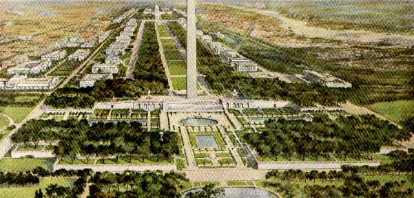
The axis of the Capitol and Monument is clearly defined by an expanse of undulating green a mile and a half long and three hundred feet broad, walled on either side by elms, planted in formal procession four abreast. Bordering this green carpet, roads, park-like in character, stretch between Capitol and Monument, while beneath the elms one may walk or drive, protected from the sun. Examples of this treatment abound in England and on the Continent of Europe, and also may be found in our own country in those towns, both North and South, which were laid out during the colonial era. Moreover, these two plantations of elms traversed by paths are similar in character to the Mall in Central Park, New York, which is justly regarded as one of the most beautiful features of that park.
The American elm was chosen not only because of the architectural character of its columnar trunk and the delicate traceries formed by its widespreading branches, but also because in the District of Columbia this tree is at its best, notable examples being found in the city parks and in the grounds of the Capitol.
The streets leading southward from Pennsylvania avenue are to cross the Mall at their present grades, no attempt being made either to exclude street car and other traffic or to hide it. Indeed, the play of light and shade where the streets break through the columns of trees, and the passage of street cars and, teams give needed life to the Mall, while at the same time those persons most interested in the area maintained as a park will obtain the full enjoyment from it. As the Garden of the Tuilleries, besides performing its artistic function of uniting the palaces of the Louvre with the Arc de Triomphe, furnishes a pleasing passageway for tens of thousands of persons who cross it going to and from their work, so the Mall will afford variety and refreshment to those going and coming between the "Island" and the other sections of the city.
By extending Ninth street through the Mall, an opportunity occurs to
emphasize these very necessary north and south connections, and at the
same time to relieve from monotony the meadow-like stretch a mile and a
half long. The entire space between Seventh and Ninth streets should be
treated in a manner similar to the proposed Union Square in front of the
Capitol, with parterres of green and large basins of water, with frequent
seats tempting the passer-by to linger for rest.
The Washington Monument Division
From this cross axis the carpet of greensward of the Mall stretches westward. The bordering columns of elms march to the Monument grounds, climb the slope, and, spreading themselves to right and left on extended terraces, form a great body of green, strengthening the broad platform from which the obelisk rises in majestic serenity. The groves on the terraces become places of rest, from which one gets wide views of the busy city; of the White House, surrounded by its ample grounds; of the Capitol, crowning the heights at the end of the broad vista; of sunny stretches of river winding at the foot of the Virginia hills.
 Click for larger image
Axial relations between the White House and the Monument are created by the construction of a sunken garden on the western side of the great shaft, the true line passing through the center of a great round pool, to which marble steps three hundred feet in width lead down forty feet from the Monument platform. Surrounded by terraces bearing elms, laid out with formal paths lined by hedges and adorned with small trees, enriched by fountains and temple-like structures, this garden becomes the gem of the Mall system. Seen from the lower level, the Monument gains an additional height of nearly forty-five feet, while at the same time nothing is suffered to come so near as to disturb the isolation which the Monument demands.
At present the immediate surroundings of the Monument are so inadequate as to cause the beholder near at hand to lose that very sense of grandeur which it inspires when seen from a distance; and the lack of harmonious relationship between it and the great structures with which it comes into juxtaposition disturbs one's sense of fitness. No portion of the task set before the Commission
has required more study and extended consideration than has the solution of the problem of devising an appropriate setting for the Monument; and the treatment here proposed is the one which seems best adapted to enhance the value of the Monument itself. Taken by itself, the Washington Monument stands not only as one of the most stupendous works of man, but also as one of the most beautiful of human creations. Indeed, it is at once so great and so simple that it seems to be almost a work of nature. Dominating the entire District of Columbia, it has taken its place with the Capitol and the White House as one of the three foremost national structures.
The Washington Common
Taking the Monument garden as a center, one looks northward over the White Lot, which is retained as the great drill grounds of the District. On the east and on the west, along Fifteenth and Seventeenth streets, walks shaded by four rows of lindens tempt one from the hot and busy streets of the city to the cool and quiet of the gardens or to the field of sports beyond.
The space south of the Monument is to be devoted to the people as a place of recreation--the Washington Common it might be called. Here should be constructed a great stadium arranged for athletic contests of all kinds and for the display of fireworks on festal occasions. Ball grounds and tennis courts, open-air gymnasiums for youths, and sand piles and swings for children, all should be provided, as they are now furnished in the progressive cities of this country. The tidal basin should have the most ample facilities for boating and for wading and swimming in summer, as well as for skating in winter. To this end boat pavilions, locker houses, and extensive bath houses should be constructed with all the conveniences known to the best-equipped institutions of like character. The positive dearth of means of innocent enjoyment for one's leisure hours is remarkable in Washington, the one city in this country where people have the most leisure.
Where the axis of the White House intersects the axis of Maryland avenue a site is found for a great memorial. Whether this memorial shall take the form of a Pantheon, in which shall be grouped the statues of the illustrious men of the nation, or whether the memory of some individual shall be honored by a monument of the first rank may be left to the future; at least the site will be ready.
The Lincoln Memorial
The area extending westward for a mile from the Monument to the bank
of the Potomac--land reclaimed from the river flats-- remains to be considered.
For the most part this area from New York avenue to the river should be
treated as a wood, planted informally, but marked by formal roads and paths,
much as the Bois de Bologne at Paris is treated. If the plans as laid down
by this Commission shall be observed by the army engineers in the remaining
work of flats reclamation, and by the District engineers when they come
to complete the sewage-disposal system, this portion of the Potomac Park
can be made ready for planting without appreciable expense.
 Click for larger image
The central portion of this area, still adhering to the Mall width of sixteen hundred feet, has a special and particular treatment. From the Monument garden westward a canal three thousand six hundred feet long and two hundred feet wide, with central arms and bordered by stretches of green walled with trees, leads to a concourse raised to the height of the Monument platform. Seen from the Monument platform, this canal, similar in character and general treatment to the canals at Versailles and Fountainebleau, in France, and at Hampton Court, in England, introduces into the formal landscape an element of repose and great beauty. At the head of the canal a great rond point, placed on the main axis of the Capitol and the Monument, becomes a gate of approach to the park system of the District of Columbia. Centering upon it as a great point of reunion are the drives leading southeast to Potomac Park and northwest by the Riverside drive to the Rock Creek system of parks. From this elevation of forty feet the Memorial Bridge leads across the Potomac directly to the base of the hill crowned by the Mansion-house of Arlington.
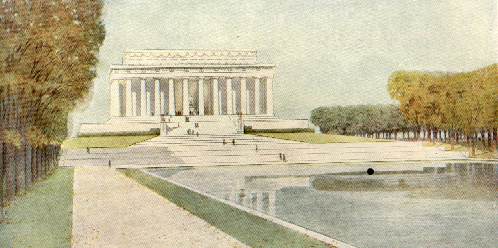
Crowning the rond point, as the Arc de Triomphe crowns the Place de l'Etoile at Paris, should stand a memorial erected to the memory of that one man in our history as a nation who is worthy to be named with George Washington--Abraham Lincoln.
Whatever may be the exact form selected for the memorial to Lincoln, in type it should possess the quality of universality, and also it should have a character essentially distinct from that of any monument either now existing in the District or hereafter to be erected. The type which the Commission has in mind is a great portico of Doric columns rising from an unbroken stylobate. This portico, while affording a point of vantage from which one obtains a commanding outlook, both upon the river and eastward to the Capitol, has for its chief function to support a panel bearing an inscription taken either from the Gettysburg speech or from some one of the immortal messages of the savior of the Union.
The portico contemplated in the plans, consisting of columns forty feet in height, occupies a space of two hundred and fifty feet in length and two hundred and twenty feet in width; it is approached by flights of stairs on the east and the west, is embellished with appropriate groups of sculpture, and is surmounted by a central crowning group of statuary. At the head of the canal, at the eastern approach to the memorial, it is proposed to place a statue of Abraham Lincoln, while surrounding the memorial and framing it are linden trees, planted four rows deep, to form a peristyle of green, from which radiate various avenues centering upon the memorial itself.
THE MEMORIAL BRIDGE, ANALOSTAN ISLAND AND THE NATIONAL CEMETERY AT ARLINGTON
On the occasion of laying the corner stone for the extension of the Capitol, on the Fourth of July, 1851, Daniel Webster, in the course of an impassioned plea for preservation of the Union, which in his prophetic vision seemed even then on the verge of dissolution, exclaimed:
"Before us is the broad and beautiful river, separating two of the original thirteen States, which a late President, a man of determined purpose and inflexible will, but patriotic heart, desired to span with arches of ever-enduring granite, symbolical of the firmly established union of the North and the South. That President was General Jackson."
The struggle which the orator and the statesman were powerless to avert brought about the perpetuation of the Union; and to-day the survivors of that war, both those of the North and those of the South, using the words of President McKinley, urge the building of the Memorial Bridge as a monument to American valor.
For the past seventeen years the Memorial Bridge project has been before Congress constantly. In response to the Senate resolution of May 24, 1886, Major Hains, of the Corps of Engineers, reported in favor of a bridge of four spans, each about three hundred feet in length, to extend from the Washington bank of the Potomac to Analostan Island, the island itself and the bed of Little River to be crossed partly by an embankment and partly by an open trestle, the cost for the entire work to be about $650,000. About the same time Captain Symons submitted a plan for a more elaborate structure, to extend from Observatory Hill to the National Cemetery and Government estate at Arlington, at a cost of $1,500,000. On February 20, 1890, the Senate again called for a study of the subject, and in response Colonel Hains proposed a bridge four thousand five hundred and eighty feet in length, extending from New York avenue to the Arlington estate, at a cost of $3,591,000.
Subsequently several reports were made on bills to provide for a Memorial Bridge, but the first legislation on the subject is found in the sundry civil act approved March 3, 1899, which appropriated $5,000, "to enable the Chief of Engineers of the Army to continue the examination of the subject and to make or secure designs, calculations, and estimates for a Memorial Bridge from the most convenient point of the Naval Observatory grounds, or adjacent thereto, across the Potomac River to the most convenient point of the Arlington estate property."
Acting under the authority so conferred, four bridge engineers, Messrs. L. L. Buck, William H. Burr, William R. Hutton, and George S. Morrison, were invited to prepare plans. These plans were submitted to a jury composed of Lieutenant Colonel Charles J. Allen, Major Thomas W. Symons, Captain D. D. Gaillard, of the Corps of Engineers, and Mr. Stanford White and Mr. James G. Hill, architects, who reported in favor of a combination of the designs submitted by Professor Burr. The cost was estimated at $4,860,000, and the structure proposed was a highly decorated bridge eighty-four feet in width, adapted for street-railway tracks, and fitted with a steel bascule draw. These plans were submitted to Congress by the Secretary of War on April 9, 1900, but thus far no action upon them has been taken.
Up to the time this report was submitted no study had been made for the development of the Potomac Park, and for this reason, doubtless, favorable consideration was given to bridge plans which contained in themselves features unusually elaborate. The studies which the Park Commission has made for the improvement of Potomac Park, and the introduction in the park proper of memorials of the largest type, have led the Commission to recommend certain modifications in both the location and the character of the Memorial Bridge.
The proposed Lincoln memorial, located on the bank of the Potomac, on the axis of the Capitol, and the Washington Monument, and occupying an elevation forty feet above the level of the water, makes a starting point for the bridge that becomes especially convenient when this rond point is considered as the point of divergence and reunion of the driveways leading to the Rock Creek park system on the northwest and the Potomac system on the southeast. Moreover, the establishment of this concourse allows the bridge to cross the river at the angle most convenient, taking into consideration both the channel of the river and the main objective point--the mansion house at Arlington.
Inasmuch as the comparatively flat topography of the country makes undesirable a high bridge under which vessels could pass, the decreased length of bridge required under the new plans is in itself a weighty consideration. At the same time the necessity of placing a draw in the bridge calls for such a treatment of the spans as shall not result in an apparent weakening of the structure at its central and vital point.
All these things considered, the Commission recommends that the Memorial Bridge proper begin at the proposed Lincoln memorial and extend to Analostan Island; that the supports be masonry piers of monumental character; that the spans be so arranged as to present a uniform appearance, the character of the draw used being such as to bring about this result. Also, that a concourse suited to memorial treatment be established on Analostan Island, and that the extension of the passageway from the island to the Virginia shore be distinctly subordinate to the bridge proper.
The competition already mentioned having resulted in the selection of one of the leading bridge builders of the country, it is not considered necessary to do more than to have the subject restudied in the light of the new conditions and to have such modifications made in the plans as shall adapt them to the principles above laid down, all of which may be accomplished under the direction of the Secretary of War when the necessary appropriations shall be made. Such modifications would call for the removal of the central ornamental towers, which would conflict with the proposed Lincoln memorial, and which are not considered as in themselves desirable features for the central portion of a bridge structure.
In connection with the Memorial Bridge, the acquisition and development of Analostan Island becomes an important consideration. The island proper is about eighty-eight acres in extent; and to this should be added the flats at the eastern end, which must be reclaimed eventually. The western portion, separated from Georgetown by the narrow channel of the river, is in part covered by trees and in part by sedges and water plants. Forming an important and beautiful part of all the views over the Potomac, the island should not be permitted to come into disagreeable occupancy, but at the earliest convenient opportunity it should be purchased and developed as a river park for the use of that portion of Georgetown which is now entirely without park facilities. Inasmuch as the island will be crossed by the Memorial Bridge, it will be accessible, and at its present offered price it would form a very desirable and inexpensive addition to the park system.
The broader and simpler the treatment of the bridge to Arlington the closer will be the connection between the reservations now separated by the Potomac, and the more vital will be the relation between the Potomac Park and the Arlington estate. Such a result becomes desirable in the highest degree when one considers the immense numbers of people who resort not only to Fort Myer, but also the Arlington Cemetery.
The interest excited by the drills at the cavalry post, the superb view from the heights, and the feelings of patriotism awakened by the vast field of the hero dead, known or unnamed, all call for such a treatment of the entire reservation as shall not diminish but rather enhance the effect produced on the visitor.
There is nothing that needs proper supervision and planning more than the modern cemetery, for there is certainly nothing that suffers more from vulgarity, ignorance, and pretentiousness on the one side, and grasping unscrupulousness on the other; and instead of being a place to which one may go with a sentiment of respect and peace, as into a church or sacred place, the eye and the feelings are constantly shocked by the monstrosities which dominate in all modern cemeteries.
There is no doubt that the feeling which pervades the majority of people who erect monuments to their dead is one of the tenderest; a sincere desire to do nothing even in the simplest form which is not fitting and in entire harmony with the feeling that prompts the erection of the memorials. This feeling, if properly protected and guarded, would lead to the harmonious and sober treatment so necessary for such places. A great example of the effectiveness of such restraint and guidance is the extraordinary dignity, impressiveness, and nobility of the Soldiers' Cemetery at the Soldier's Home in this city, and also in that part of the Arlington Cemetery set apart for the privates and unknown dead. This is not attained by any large monuments, but by the very simplicity and uniformity of the whole.
The trouble is that the majority of monuments now in the cemeteries are produced by firms who make it merely a business affair, the greater portion of them having not the slightest idea of what is good or bad, and possessing not even an elementary knowledge of architecture or even good taste. To remedy this it is absolutely necessary that the designs for all the monuments in all the cemeteries, from the most modest to the most costly, should be made by or subject to the approval of a commission composed of two or three architects and a landscape architect of the highest possible standing. They should lay out and design the cemeteries and establish rules for their proper supervision, and should control the designs for future monuments in the cemeteries already existing.
Nothing could be more impressive than the rank after rank of white stones, inconspicuous in themselves, covering the gentle, wooded slopes, and producing the desired effect of a vast army in its last resting place. Those spaces reserved for burials of officers and their families, however, exhibit all the heterogeneous forms which disturb those very ideas of peace and quiet which should characterize a spot sacred to the tenderest feelings of the human heart. In particular, the noble slopes toward the river should be rigorously protected against the invasion of monuments which utterly annihilate the sense of beauty and repose. This is one of the most beautiful spots in the vicinity of Washington; it should not be defaced or touched in any way, and a law or rule should at once be passed forbidding the placing of any monument on this hill.
THE GROUPING OF THE BUILDINGS OF THE EXECUTIVE DEPARTMENTS
The location of the buildings connected with the Legislative and Judicial Departments of the Government having been discussed in another portion of this report, attention should be given to the buildings of the Executive Department. Of these the first to be considered is the White House, the corner stone of which was laid on October 13, 1792, and which was first occupied by President and Mrs. John Adams in 1800. The building was burned by the British in 1814, and both its construction and reconstruction were superintended by its architect, James Hoban.
For a number of years past the White House has been overcrowded by reason of the rapid increase in public business, which has encroached seriously upon the private apartments of the President. The larger receptions and other social functions are now so inadequately provided for as to cause serious discomforts to the guests, and a consequent loss of that order and dignity which should characterize them. State dinners can not be served adequately; and all the conditions surrounding the home life of the President are primitive to the last degree.
Three methods of overcoming the present unfortunate conditions have been suggested: First, the enlargement of the White House by additions on the east and west of the present building. The plans and model prepared for such enlargement prove conclusively that the historic White House can not be enlarged without destroying its individuality, thus causing the loss of those characteristic features which endear the edifice to the American people. Second, it has been urged that the White House be given up entirely to public business, and that a residence for the President be built on one of the commanding hills overlooking the city. This plan, however, has not as yet commended itself to popular opinion.
The third alternative is that the Executive offices be removed from the White House, and that the Presidents House (as the White House was termed officially until about 1860) be devoted entirely to residence purposes. This latter plan is favored by the present Chief Executive; and to the Commission it seems to be the best solution of the problem possible at this time.
The location of the building to contain the Executive offices is a more difficult matter; but the Commission are of the opinion that while temporary quarters may well be constructed in the grounds of the White House, a building sufficient in size to accommodate those offices may best be located in the center of Lafayette Square. This suggestion must be taken in connection with the full development of the plan outlined below.
There is a present and pressing need for new buildings for existing Departments. The Department of Justice is without a home, and the site selected for a new building (a portion of the square opposite the Treasury Department) is admitted to be inadequate for the erection of a suitable structure. The State, War, and Navy Departments, now housed in a single building, are in so crowded a condition that they are occupying additional rented quarters. For the sake of convenience these Departments should be accessible to the White House, which is their common center. The proper solution of the problem of the grouping of the Executive Departments undoubtedly is to be found in the construction of a series of edifices facing Lafayette Square, thus repeating for those Departments the group of buildings for the Legislative and Judicial Departments planned to the Capitol grounds. Certainly both dignity and beauty can best be attained by such a disposition of public edifices.
The execution of this plan may best begin by erecting on the entire square bounded by Pennsylvania avenue, Jackson place, H, and Seventeenth streets a building for the use of the Departments of State and of Justice. The square opposite the Treasury Department will be required before many years by the Post-Office Department, now most unworthily and inadequately housed in rooms over the local postoffice; and by the Department of Commerce, soon to be created. It is quite possible also that the Interior Department may find it most convenient to give up to the growing needs of the Patent Office its present noble building, and to come into closer physical relations with the other Executive Departments. The Agricultural Department, however, being the nucleus of a great number of laboratories requiring a maximum of light and air, may properly have its new building located, as at present proposed, on the grounds in the Mall, now set apart for its uses.
Such a group of buildings, with the Executive offices for a center, as the Capitol is the center of the Legislative group, will result in a composition of the greatest possible dignity and impressiveness.
THE AREA SOUTH OF PENNSYLVANIA AVENUE
During the past two decades a sentiment has developed both among the residents of the District and also in Congress, that the area between Pennsylvania avenue and the Mall should be reclaimed from its present uses by locating within that section important public buildings. The avenue itself is one of the historic thoroughfares of the world, a preeminence attained by reason of the fact that it connects the Executive Department with the Legislative and Judicial Departments of Government, and so has become the route of those processions which celebrate great occasions in peace and war, or which from time to time mark the change of Administrations. Although within recent years imposing buildings devoted to business purposes have been erected on the north side of the avenue, nevertheless, for the most part, the thoroughfare, spacious as it is in itself considered, is lined by structures entirely unworthy of the conspicuous positions they occupy. The upbuilding of Pennsylvania avenue, therefore, must of necessity have consideration in any comprehensive plan for the treatment of Washington.
The extension of B street north eastward to Pennsylvania Avenue, and the inclusion within the Mall of the space south of that street, as extended, will in part solve the problem. Furthermore, the present location of the city post-office and of the great central market, together with the fact that the business of the city is concentrated largely along this avenue, both suggest that within this area the public buildings of the municipality, as distinct from the General Government, may well be located. The Commission have the more confidence in making this recommendation for the reason that, by common consent and by positive action as well, a site for a District building was set apart in front of the present Center Market, and for nearly thirty years the District of Columbia virtually has been paying an annual rental for that site, in the decreased rents charged the market company in consideration of the relinquishment of a portion of their property to be used as the site of a municipal building. Inadequate as to size, the location of the site is especially adapted to the end sought. Occupying a position midway between the White House and the Capitol, situated at the point of convergence of wide avenues, located in the very center of business activity, placed on a line with the dignified building of the Department of the Interior and of the new Carnegie Library, the site selected would give to the District building and to the municipality it represents a distinction and a dignity all its own. No other site would so assert the individuality of the District of Columbia. This individuality would be still further enhanced by grouping within the same general area other buildings municipal or semi-municipal in character. In this connection the axial relation existing between the proposed site and the present location of the District courts should not be overlooked.
The location of the District building at the point named would bring about a much-needed change in market conditions. As at present conducted, a large portion of the market business is conducted in public thoroughfares, to the inconvenience of travel and to the disturbance of municipal good order. Congress having retained an option of purchase, the market may well be removed to a location west of the present one, where could be provided a sufficient area, within which territory the business could be conducted within the market itself without encroaching upon the public thoroughfares. This new market should be constructed with streets running through it, as in the case in the admirable examples at Paris, Budapest, and other cities of continental Europe.
Within the same general area should be constructed an armory sufficient in size to accommodate the brigade of District militia; and since the inauguration of the President of the United States is regarded as a municipal and not as a national function, the armory should be of a character to accommodate the inaugural balls now, given in the Pension Bureau, to the disturbance of public business.
Also the much-needed new police court, the police and fire headquarters, an enlarged emergency hospital, and other like divisions of civic administration should find local habitations in immediate proximity to the District building.
In such manner, gradually, and as municipal needs become insistent, the entire space should be occupied, transformed from its present unworthy conditions into a section having a distinct character, and also being closely related to its environment.
| Selected, scanned, edited, provided with headnotes, and formatted as a web document by John W. Reps, Professor Emeritus, Department of City and Regional Planning, West Sibley Hall, Cornell University, Ithaca, New York 14853, USA. Tel: (607) 255-5391, Fax: (607) 255-6681, E-mail: jwr2@cornell.edu |